The Newton County (Missouri) Health Department has resumed water quality testing in the Shoal Creek Watershed. They are sampling every 2 weeks. They have identified twenty-two different test sites on Baynham Branch, Beef Branch, Capps Creek, Carver Branch, Cedar Branch, Clear Creek, Hickory Creek, Spring Creek, Silver Creek, Thurman Branch, and Shoal Creek. Here is the link to their
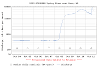
E. coli test data. Here is the link to a
map of their test sites.
Site #/Stream-Creek Name (numerical)#6, Shoal Creek at Tipton Ford CA
7, Cedar Branch on Old Scenic Road
8, Baynham Branch on Lime Kiln Rd.
9, Carver Branch on Lime Kiln Rd.
20, Shoal Creek at Old HWY E, Granby
21, Shoal Creek at Cherry Comers CA
23, Shoal Creek at HWY W, Ritchey
24, Shoal Creek at Smack Out Rd.
26, Capps Creek at Capps Creek CA
51, Hickory Creek on BUS HWY 60
52, Shoal Creek at Lime Kiln CA
68, Beef Branch on Cedar Rd.
88, Clear Creek at Walleye Rd.
93, Capps Creek below Jolly Mill dam
94, Shoal Creek in Wildcat Park
114, Silver Creek on 44th St.
115, Silver Creek in Wildcat Park
116, Thurman Branch on Gateway Dr.
117, Thurman Branch on Shoal Creek Dr.
118, Beef Branch on Cedar Rd.
119, Spring Creek in Reddings Mill
120, Shoal Creek upstream from Falls
Stream-Creek Name /Site # (alphabetical)Baynham Branch on Lime Kiln Rd., #8
Beef Branch on Cedar Rd., #68
Beef Branch on Cedar Rd.m #118
Capps Creek at Capps Creek CA, #26
Capps Creek below Jolly Mill dam, #93
Carver Branch on Lime Kiln Rd., #9
Cedar Branch on Old Scenic Road, #7
Clear Creek at Walleye Rd., #88
Hickory Creek on BUS HWY 60, #51
Shoal Creek at Tipton Ford CA, #6
Shoal Creek at Old HWY E, Granby, #20
Shoal Creek at Cherry Comers CA, #21
Shoal Creek at HWY W, Ritchey, #23
Shoal Creek at Smack Out Rd, #24
Shoal Creek at Lime Kiln CA, #52
Shoal Creek in Wildcat Park, #94
Shoal Creek upstream from Falls, #120
Silver Creek on 44th St., #114
Silver Creek in Wildcat Park, #115
Spring Creek in Reddings Mill, #119
Thurman Branch on Gateway Dr., #116
Thurman Branch on Shoal Creek Dr., #117
For more information,contact:
Newton County Health Department
812 W. Harmony Street
Neosho, MO 64850
ph: 417-451-3743
fax: 417-451-1852
alt: 417-451-6549 Environmental Dept.
administration@newtoncountyhealth.org